The Circle Line

Walks, England, Greater London, City of Westminster

Preview Steps

Download the app to get all the steps for this walk.

Map preview for The Circle Line
  • Start at Baker Street Station and find your nearest street map. Your next stop will be Edgware Road!

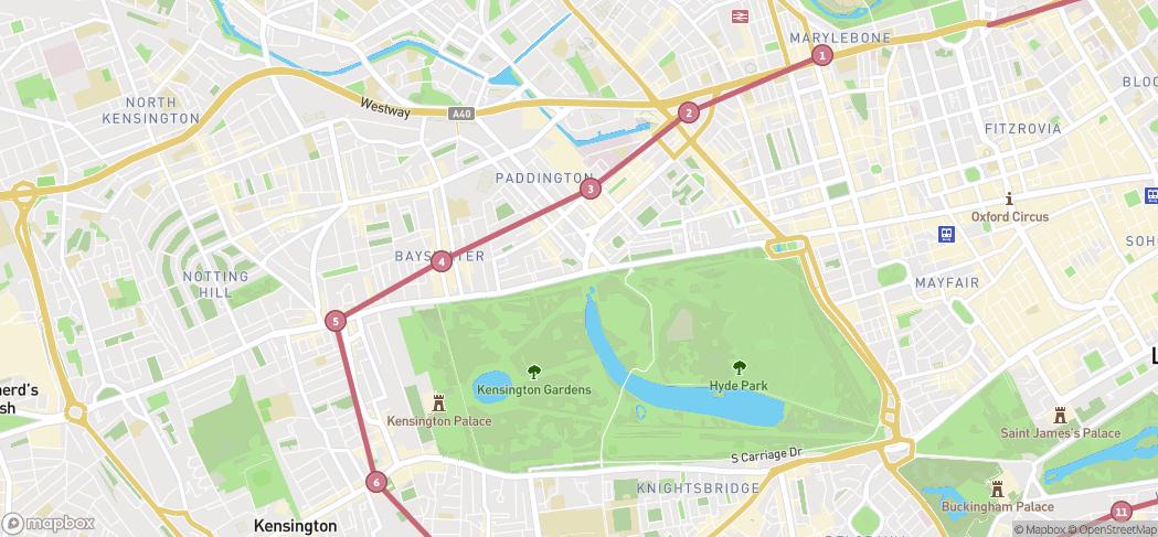
    Step 1: Start at Baker Street Station and find your nearest street map. Your next stop will be Edgware Road!

  • Once you’ve got to Edgware Road, head towards Paddington

    Step 2: Once you’ve got to Edgware Road, head towards Paddington

  • Now you’ve reached Paddington, you need to get to Bayswater!

    Step 3: Now you’ve reached Paddington, you need to get to Bayswater!

  • I found it a bit tricky to find Bayswater since I’m not that familiar with that end of London, but it’s then onto Notting Hill Gate

    Step 4: I found it a bit tricky to find Bayswater since I’m not that familiar with that end of London, but it’s then onto Notting Hill Gate

  • Notting Hill Gate is actually underground, so you’ll be looking for a subway! After that it’s onto High Street Kensington

    Step 5: Notting Hill Gate is actually underground, so you’ll be looking for a subway! After that it’s onto High Street Kensington

  • You’ll be amongst a lot of people by this point, you’re now going to head towards Gloucester Road

    Step 6: You’ll be amongst a lot of people by this point, you’re now going to head towards Gloucester Road

Download the app to get all the steps for this walk.

Nearby Walks

  • Preview of A Womble around Baker Street

    A Womble around Baker Street

    City of Westminster, London

    by projectwomblelondon

    by projectwomblelondon

    1hr 45m / 4.7km
    A Blue Plaque trail of Marylebone, starting at Baker Street Underground Station.
    Refreshments Public transport History
  • Preview of Regent's Park to Primrose Hill

    Regent's Park to Primrose Hill

    Regents Park, London

    by GoJauntly

    by GoJauntly

    1hr 16m / 4.4km
    A calming walk where you can catch a breathtaking view of London. Take the tube to Baker Street, Great Portland Street or Regents Park.
    Public toilets Refreshments Wheel friendly Great views Hilly & steep Public transport
  • Preview of Meandering in Marylebone

    Meandering in Marylebone

    Marylebone, London

    by rshenderson

    by rshenderson

    2hr 30m / 3.9km
    Stroll from Marylebone through Regents Park to Primrose Hill and enjoy the sights, shops, cafes and pubs along the way.
    Picnic spot Refreshments Great views Child friendly Water feature Public transport
  • Preview of Amazing Regent's Park

    Amazing Regent's Park

    Regent's Park, London

    by mikaela

    by mikaela

    1hr 5m / 1.9km
    Saturday strolling through a sunny and blossoming Regent's Park.
    Public toilets Picnic spot Refreshments Wheel friendly Water feature Public transport
  • Preview of Regents Park South

    Regents Park South

    Regents Park, London

    by mrjamieboyd

    by mrjamieboyd

    35 minutes / 2.7km
    A good lunch time walk through The Avenue Garden and Queen Mary’s Gardens.
    Public toilets Picnic spot Refreshments Wheel friendly Child friendly Water feature
  • Preview of The Bee Walk

    The Bee Walk

    The Regent's Park, London

    by missioninvertebrate

    by missioninvertebrate

    45 minutes / 2.4km
    Buzz through The Regent's Park and immerse yourself in the world of bees, bugs and dragonflies.
    Wildlife Wheel friendly Great views Public toilets Child friendly Botanics

Cookie consent

Using our site means you agree to the use of cookies and similar technologies.

Read more and how to disable cookies in our Privacy Policy